Saturday, January 23, 2016

Wide Open Spaces in Southern California


The high desert of Joshua Tree National Park looking west toward Los Angeles
The 'trees' are actually giant Yucca
Where does the time go? It's difficult to believe my last post was three weeks ago. We have been to some marvelous places. After leaving Picacho State Preserve, we spent one night in Quartzite. I wasn't prepared for the number of motorhomes and the profusion of vendors selling everything from rocks and gems to Chinese antiques and generators. However, that was about all there is to the place. I wanted to celebrate Sarah's birthday at a nice restaurant, but after checking the menus at every eating establishment in the town, the best we could do was an acceptable pizza at Silly Al's. One would think with the number of big rigs in the area there would be at least one place to dine that wasn't a "family restaurant". Our impression was even less favorable as we walked around the flea market tents and more than once heard racist and vulgar comments openly made about President Obama. I dared not give a sideways look let alone engage those making the comments.

Fortunately, Blythe, California is just a short drive to the west and is where we had reservations for the 29th annual Blythe Bluegrass Festival and we were allowed to camp at the fairgrounds as early as the Monday before the festival started. Initially, we planned on arriving in Blythe on Wednesday, but were happy to leave Quartzite and secure space for ourselves and our friends from home, Jack and Liz who joined us for the festival.

There were a number of excellent bands showcased on two stages. The music on stage started early and ended just at  sundown when the cold of the desert descended on the fairgrounds. But, there was plenty more music each evening in heated tents or around the portable wood stoves that were provided for the campers. In the campgrounds, the vast majority of campers were in massive motorhomes, many of which ran generators continually from 7AM until 10PM.
Good bluegrass under blue skies
While we enjoyed the festival, Sarah and I could only endure hearing some bluegrass standards so many times in such a short period. So, we left early on Sunday and headed for Joshua Tree National Park where we were to meet with Sarah's sister and brother-in-law, Jennifer and Topher, who drove from Oregon to spend a week with us. Choosing the Cottonwood Campground because it was closest to Blythe turned out to be fortuitous because we had forgotten that due to MLK day, it was a long weekend and the other campgrounds were full. Even still, we had to spend time carefully maneuvering the Mary Joan's 31 feet into one of only a few sites remaining that could accommodate us. The camp host even remarked on how well we did.
Hiking up the Mastadon trail in Joshua Tree National Park from Cottonwood Campground
Abandoned mine on the Mastodon trail. We climbed the big boulder mound for a fine view of the Salton Sea
View from the top of Mastodon trail, looking west over the Salton Sea toward San Diego

Much of what Joshua Tree has to offer requires driving so we combined sightseeing with a drive into the town to purchase some provisions and access the internet to retrieve e-mails. Since we wanted to move to a campground at the northern end of the park and knowing that there were not many sites large enough to accommodate us, we drove through two other campgrounds to scout out our next site. At the Belle campground we found a spacious campsite that was large enough to hold the Mary Joan, our truck and our guests' car.
Our campsite at Belle campground. Jennifer likes this place.
Looking west from Joshua Tree
Key's view at Joshua Tree. Looking west across the San Andreas fault and Palm Springs
Because Jennifer and Topher needed to begin their return to Oregon in just a couple days, we chose to go next to Mojave National Preserve for one night then on to Death Valley from where they would leave us to go home. As so often happens, the decision was a fortunate one because our tow vehicle's starter began to act up. With good phone service and internet at the Texas Spring campground in Death Valley, I made a reservation to stay at the RV park at Circus Circus and an appointment with the Ford dealer in Las Vegas to repair the truck.

Old Route 66 Motel

Roy's is currently an art installation addressing the drought in California. Don't ask what's in those bottles.

At Hole In The Wall Campground (Mojave National Preserve) Sarah is happy to find PETROGLYPHS

Hiking the Ring Loop Trail in Mojave National Preserve

Gas pockets left after massive volcanic explosion
It's called the Ring Loop Trail because of the hand holds needed to climb out of the canyon
Sunset in Mojave Desert
The drive into Death Valley offered a continual display of multicolored mountains. I visited this place 25 years ago, but had forgotten how beautiful this place is.

Death Valley near Furnace Creek, Death Valley

Early morning hike into Golden Canyon, Death Valley

View from Golden Canyon, Death Valley

Red Cathedral in Golden Canyon, Death Valley
We plan to return to Death Valley after having the truck repaired.
Stay tuned


Monday, January 11, 2016

Lines on a Map


We were sad to leave our friends, Liz and Jack when we departed Bisbee. SR90 took us through Sierra Vista then to SR82 west at Sonoita where we turned north onto SR83 to take us to Empire Ranch Road and the entrance to Las  Cienegas National Conservation Area. The refuge is high desert consisting of rolling hills surrounded by mountains on all sides. Good gravel roads lead to a number of dispersed camping areas. We enjoyed the beauty and peaceful solitude of the grasslands where many western movies were filmed by stars such as John Wayne, Barbara Stanwyck and Steve McQueen. Lacking horses, we rode our bicycles 9 miles to Sonoita where we had lunch at The Steakout Restaurant and Saloon. They serve good barbecue, and from the looks of it, great steaks. That evening, we returned to enjoy a beer, listen to live music and watch the football game.
Dispersed Camping in Las Cienegas 

With rain in the forecast, and because the trails into the campsites from the gravel road were dirt, we thought it wise to not stay and test the ability of our 4 wheel drive tow vehicle to get us out of Las Cienegas. Plus, if we had to endure rain, an urban area would provide more entertainment opportunities and we could complete necessary chores, like laundry and getting the oil changed in the truck. Tucson was just a short drive so we set off for Tucson Mountain Park, where we have stayed before. The weather cooperated the day we arrived allowing us to hike  to Brown Mountain and back from the campground. The rain arrived the next day so we dropped the truck off at the Ford dealer and spent a few hours purchasing a few necessities (See's chocolates) at the nearby mall and shopping center. When we retrieved the truck, we were told that the brakes were very close to being worn out. The quote from the dealer to replace the brakes seemed a little high, but with the advantage of the internet I found a small repair shop that had high ratings and it was just a mile from the laundromat. The next day we arrived at Advantage Auto Repair on the corner of Fort Lowell Road and North Stone Ave at mid-morning and Oscar, the proprietor, promised us the work would be complete by mid-afternoon. After finishing the laundry we returned at 2:30 PM, and as promised, the truck was ready to go.

The following day, we had lunch with Sarah's professor from graduate school, Eleanor, and her partner, Michael. After lunch, Michael delighted us by showing his collection of automatas. He has amassed an amazing array of intricately crafted objects designed to create movement in these fanciful 'toys' simply by turning a hand crank. See Michael's website to watch them come to life.

The lure of more petroglyphs was too strong to resist, so we headed for Painted Rock Petroglyph Site about 150 miles west of Tucson Mountain Park. Painted rocks are a misnomer for this site. The rock art here are petroglyphs. The ancient nomadic peoples that traveled along the Gila river here used stones to chip away at the dark oxidation, known as desert patina, that covers the exposed rocks leaving thousands of intricate figures and designs. The campsites were exceptionally large, ours was at least 100 feet square and provided great views of the distant mountains.
Huge campsite at Painted Rock Petroglyph Site
Not your average pile of desert rock
Thousands of petroglyphs
A mixture of cultures
Our next destination was Quartzite where we intended to check out the gem and stone dealers while waiting to go on to Blythe for the Blythe Bluegrass Festival. But, needing to re-provision and being close to Yuma, we took advantage of the large city's fine grocery store to stock up. Rather than drive another 80 miles north to Quartzite, and noting Picacho State Recreation Area, in California, was just 24 miles north we decided to stop there for the night. "Beside's", said Sarah while holding the atlas, "there is a scenic road we can take that will bring us directly from there to Blythe". The road from Yuma to Picacho is gravel and it turned out to be very rough due to washboarding and we were reduced to less than 15 MPH. I told Sarah, I didn't want to drive 80 miles on this road. She assured me that the road north from Picacho was a paved road because it was drawn in red on our Rand McNally Atlas indicating it was paved. And, she said it was scenic because it had the little circles marking it as such.
A river flows through the desert
Looking east with the sun reflected on the mountains over the Colorado River
Picacho Recreation area sits alongside the Colorado River. Besides the campground host, one other camper and one person fishing, we had the place to ourselves. The campground is a pleasant surprise after traversing 24 miles of rock and desert. The lush vegetation and towering trees along the river contrasted dramatically with the surrounding desert. We enjoyed a quiet night along the Colorado River.
Our campsite at Picacho
After enjoying a warm solar-powered shower the next morning and while preparing to leave, we discovered that we had had a guest inspect our trailer the previous night. In the fine dust that settled on the bumper of the Mary Joan we discovered footprints of what appeared to be a rather large racoon. We were both very happy that we try to never leave the door to the rear storage compartment open.
Big Racoon?
Our next surprise was the 'road' that Sarah said could take us north was not a road. Rather, it was the indicator of the location of the time zone divide. Resigned to retracing our tooth jarring route, we set off for Quartzite.
See the line along the river?

Desert view from road into Picacho
Departing Picacho on the washboard road

Stay tuned.

Wednesday, January 6, 2016

Holiday in Southwest


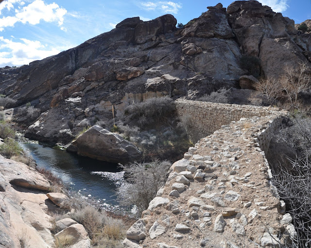
Stone dam in Huecos Tanks State Historical Park

Feeling proud for reaching Guadalupe Peak, Sarah and I rewarded ourselves with a short drive of only about 90 miles further west to Hueco Tanks State Historical Park just east of El Paso. This was a must stop because it is an area rich in ancient pictographs, which those who follow this blog know, Sarah and I enjoy viewing these ancient works and seek them out whenever possible. While the internet gives us access to a lot information, that information isn't always complete or accurate. This was the case at Hueco Tanks State Historical Park. Prior to arriving we knew that some areas were closed except to those on a guided tour, but we didn't know that hiking in the park is restricted to a limited number of visitors who register on a first come first served basis each morning. While we were allowed to go to our campsite, we were restricted to the roads in the campground until we registered with the park office the next morning. This required that we get up early and register at the park station to obtain a pass the day allowing us to explore the half of the park not closed except to those on the guided the tours. The reason for all the regulations is that at one time as many as 30,000 visitors a week were destroying this small park.
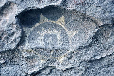
Pictograph relating the raid by Apaches
We were also surprised to learn that access into and out of the park was restricted after 6PM. The stearn Park Ranger informed us that we could not leave the park except in case of an emergency after the gate was locked at 6PM. After our stay in Guadalupe we were low on provisions and needed to drive to El Paso to re-stock. Fortunately, the campground host understood and told us not to worry about returning after the curfew.


We arrived at the Ranger Station in the morning at the appointed time and were granted access to the non-guided area. The park is unique in that it is an area of ancient limestone ocean bottom through which volcanic magma erupted. As the limestone eroded, huge mountains of lava rose from the former sea bed. Within the park are three distinct "peaks", north, east and west. We were allowed to roam the north peak at will and we shared it with rock climbers who come to boulder on the rock.

It didn't take long to understand why this park has such severe restrictions. Many of the pictographs and petroglyphs in the northern area have been defaced  over the last 100 years. We only found about six sites with pictographs, but we enjoyed climbing the steep rocks and observing all the huecos, deep depressions in the rocks that hold water and create micro-oasis in the desert.

After seeing the pictographs accessible without the guide, we enrolled for the next day's tour. We were not disappointed. Our volunteer guide, Jim, informed us that the tour's description says it lasts two hours. He said that, unless anyone in the group was on a tight schedule, the tour might be as long as three hours. There were no objections, and Jim took us on a leisurely and informative three and a half hour tour of the some very fine pictographs, not to mention the incredible scenery created by geologic forces millions of years ago.
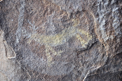
Yellow deer with white antlers

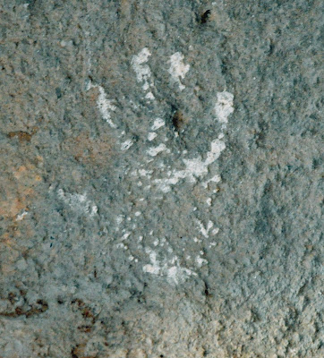
Handprint of young girl at the time of her coming of age
It was December 23, and we were to meet our co-conspirators on Christmas Eve in Bisbee, Arizona. When Sarah and I travel, we try not to have rigid plans. But, we made reservations for a week in Bisbee in order to share the holiday with our dear friends, Liz and Jack. That left us one more night on the road before making Bisbee. We usually don't know where we will spend the next night until the evening before departing our current location. I spend time with a map looking for state parks, wildlife refuges and National Parks. A few days before departing Guadalupe Mountains National Park, I spied Pancho Villa State park. The park is located in the center of the town of Columbus, New Mexico which is directly on the border with Mexico. However, I became skeptical of this town when I researched it using the internet. It seems the town nearly went bankrupt about ten years ago when a number of important people in town were found to have been criminals who ran guns to the drug cartels just across the border in Mexico and played hanky panky with the town finances. Further research on the internet revealed that the narco-criminals on the Mexican side were a rather brutal and murderous bunch. I had almost crossed this town off my list until I talked with other nomads who assured me that what I had read was ancient history and it was a perfectly safe place to visit.
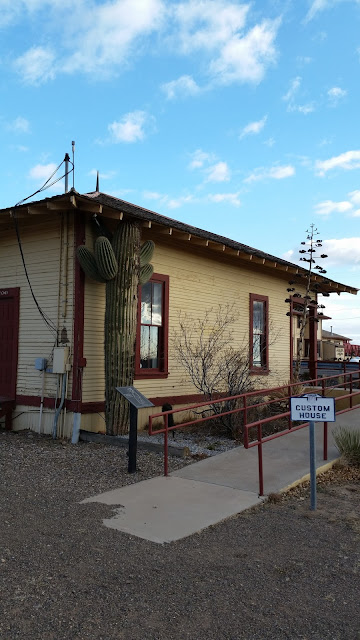
Pancho Villa State Park is an old Army Fort and Customs Station

We arrived at Pancho Villa State Park late in the afternoon, and selected one of the very large campsites available. The next morning, since Bisbee was only a few hours away, we decided to treat ourselves to breakfast in a local restaurant and then avail ourselves of the computer services of the local library. We needed to print and mail forms to cancel one of our health insurance policies due to achieving the age at which we qualify for Medicare. Unfortunately, all three cafes in town were closed on this morning of Christmas Eve. However, the library attendant told us that the Pink Store across the border in Mexico was open and serves a great huevos rancheros. She told us that we could park just on the US side and walk across the border. So, we drove the Mary Joan to the border, parked her in a large lot and walked into Mexico.
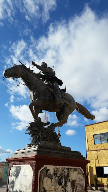
Statue of Pancho Villa in Puerto Palomas, Mexico across the border from Columbus, NM

Great coffee and huevos rancheros at the Pink Store in Palomas
 The Pink Store is a large store that sells Mexican craftworks to tourists and has a fine restaurant. We arrived while the restaurant workers were still preparing to open for the day. That gave Sarah and I time to peruse the huge assortment of items for sale. We succumbed and bought a colorful chased tin and ceramic framed mirror that should look perfect in our half bath. With shopping finished, we enjoyed some of the finest coffee we have had to accompany our huevos rancheros. Just as we finished our breakfast Sarah received a text from Liz and Jack, who left Rhode Island just four days earlier, informing us that they were closing in on Bisbee. We hit the road and arrived just about an hour after their landing.
Near Rodeo, on the border of New Mexico and Arizona
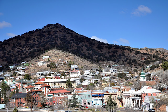
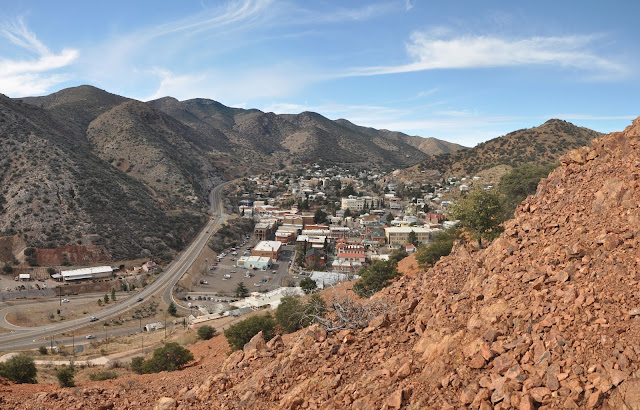
Bisbee, Arizona.
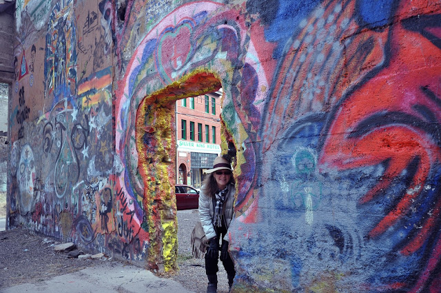
Wall art is everywhere in Bisbee


Bisbee is a former mining town that could return to its roots if the demand for and the price of copper ever sees a dramatic increase. From the late 19th century until 1975, Bisbee produced billions of tons of copper as well as significant amounts of gold, silver and lead. At its peak, it was the largest city west of St. Louis. Since the mines closed Bisbee has survived as a cool mountain oasis high in the southwest desert.
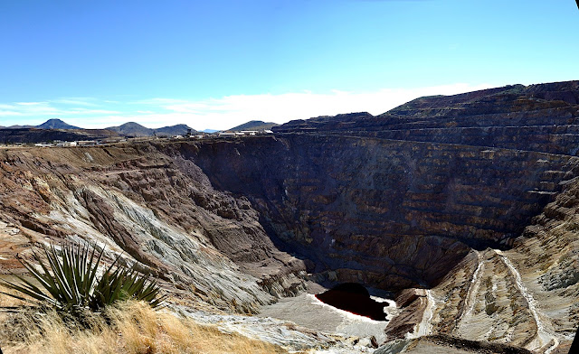
Pit mine at Bisbee

There are fine restaurants, hotels, antique stores and art galleries that attract tourists. However, the allure of Bisbee is that it is a very small community that welcomes visitors like few places we have visited. We experienced this openness when a fellow camper who has been coming to Bisbee for more than a decade invited us to a potluck music get together in the town. In just a few hours while playing music we became members of the community receiving invitations for other gatherings and expressions of disappointment that we were not going to stay longer.

Making music
We arrived on Christmas Eve and spent the week with our friends, Liz and Jack. Despite the cooler than average temperatures, we explored the streets and hiked the canyons and the peaks surrounding the old town of Bisbee.

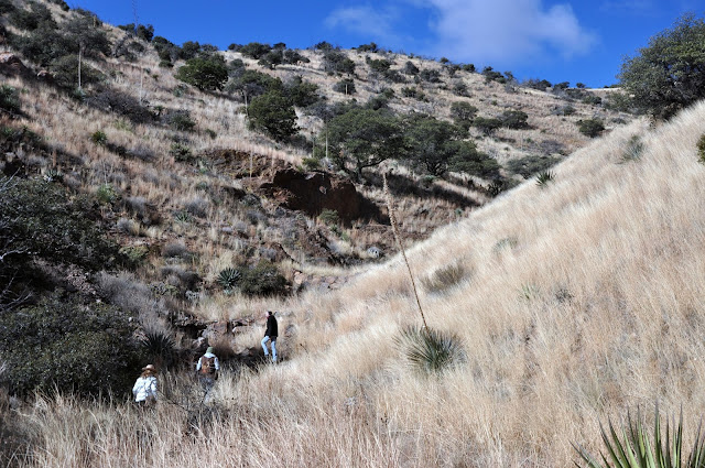
Hiking in the Bisbee canyons

One of hundreds of open mine shafts

Bisbee from Miracle Mountain
The hill across the street from our campground appeared to be just a few hundred feet above the canyon floor, just a short hike. However, owing to the steepness of the canyon walls we didn't see that the real summit was many hundreds of feet higher. Our thirty minute hike turned into a three hour sojourn to the summit of Miracle Mountain where we were enthralled with the efforts of those who sought to create memorials and shrines. Local legend told us that the first shrine was for Alfonso Velasquez whose illnesses were cured after the erection of a devotional shrine. Since then others have added to the shrines on the summit.

Miracle Mountain Summit

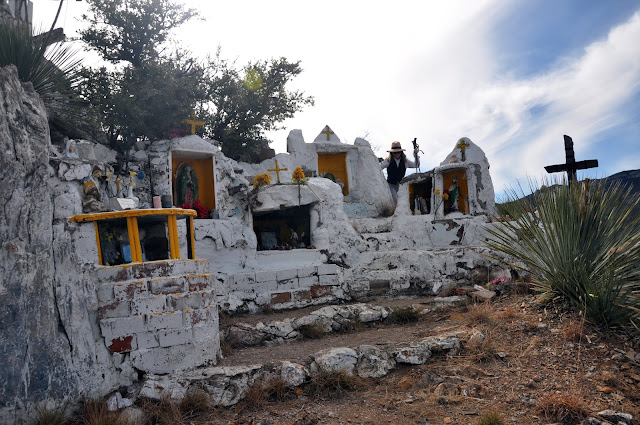
Shrine of Alfonso Velasquez


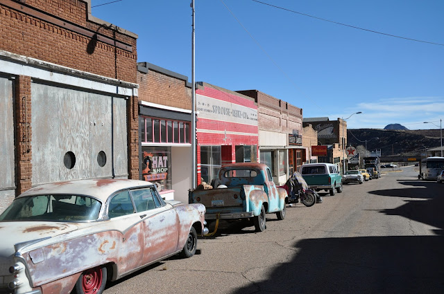
At the entrance to Bisbee's canyon is the small one street long village of Lowell. It appears that time stopped in 1975. There is a Coop market, breakfast cafe and a number of storefronts with many vintage motorcycles along with antique cars parked out front.
Lowell
Together with Liz and Jack, Sarah and I rang in the New Year drifting between three venues offering good live music and fine company after a wonderful dinner at the Copper Queen. Thanks, Jack and Liz for sharing the cheer.
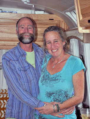
Christmas Eve with Liz and Jack

We departed Bisbee on the first day of 2016.

Stay tuned.